Asset and Vehicle Tracking
Overview
Large and small organizations can greatly benefit from knowing where valuable assets, equipment and vehicles are located along with their condition and history. Limelight XE integrates object, vehicle and asset tracking into the core engine allowing all drivers and clients to access both real-time and historical information regarding anything being tracked. Drivers support various protocols and hardware trackers for ease of deployment along with built in management features for reviewing asset or vehicle history. History can be stored in external database tables for as long as required and archived to save storage. Real time updates operate as fast as the information flows from the source - there is no delay in processing. Limelight XE's ACE engine can track and maintain information on thousands of assets (testing loads have exceeded 100,000+ assets, vehicles and objects).
Historical Object, Asset or Vehicle Data
Limelight XE™ can monitor and store multitudes of different data types per tracked object. For example, basic record keeping includes position, altitude, speed, acceleration, heading, heading course over ground (COG), heading rate of change and more. Additional data that is specific to an object type such as a vessel's draft will also be automatically stored in the history. Historical lookback is possible in the Limelight XE™ console application which can also export text or CSV formatted reports with the entire data set that can be easily imported into other applications such as Microsoft Excel for analysis.
Example vessel history information available in the Limelight XE Console application
![]()
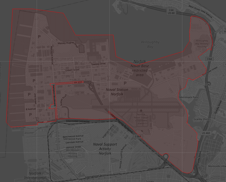
Geofencing and Area Definitions
Limelight XE's mapping and tracking features include the ability to create complex geofence shapes that follow security fencing, geopolitical boundaries, rivers and tributaries - any type of polygon that can be drawn. This can be extremely valuable to alert users when assets or vehicles enter or leave properties that have complex shapes where a simple rectangular geofence is too course. Geofences also include altitude for monitoring airspace which can be useful in applications that require the detection of low flying aircraft.
The geofencing engine calculates and maintains state information on any object nearby defined geofences and updates the database in real-time as objects move in or out of these areas. The geofencing engine also has an optional predictive modeling component that can provide earlier warnings for objects that update slowly over time. Alarms can be triggered when objects leave or arrive a geofenced area and optionally run scripts.
Example complex geofence indicating restricted areas for Norfolk Navy Base
Add Your Own Data
Limelight XE's powerful mapping features include the ability to integrate existing database tables with real-time updates. This allows users to easily integrate existing systems with the object tracking and geofencing capabilities of Limelight XE™. Data is pulled as needed from tables to keep the overhead low on your infrastructure and the mapping components only display external data when the zoom levels are appropriate (configurable to any level) to prevent information overload to operators.
External database table showing cell tower locations and type near Miami airport
